Use the main menu on the left to discover more about each individual topic - usually at the bottom of each page you will also find links to other related pages of interest. And if you're in the mood for more detailed and academic articles, why not look at our "articles" section of the main site?
Egyptology Online is constantly evolving and developing, and is updated regularly, so make sure you come back and visit us again soon!
![]()
 The land of Ancient Egypt was one of great contrasts:
The richly fertile narrow agricultural strip which runs alongside the Nile was known as "kmt" which meant "the black land", a reference to the layer of black silt deposited during the river's inundation.
The inhospitable dry and desolate desert was known as "dsrt" which meant "the red land".
Every year, between June and September, waters from the heavy summer rains from the Ethiopian highlands would flood along the course of the Nile. This was the inundation, the "akhet".
The floods would last around two weeks and then begin to subside. In their place was left a layer of fertile silt, in which the first crops would be planted around October. This was the "peret", the growing season.
Crops would ripen in March or April. This was the period when the river would reach its lowest level. This was the "shemu", the drought season.
![]()
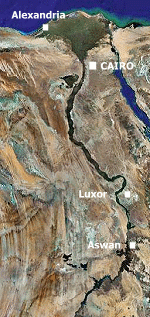
The north and the south of the country were divided, with the line being drawn roughly in the area of modern Cairo. These two kingdoms were united around the time of 3100 BC, but even to this date, the country is still known by the terms "upper" and "lower" Egypt.
|
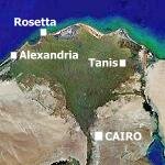
The north of the country was known as Lower Egypt, due to the fact that the Nile ran from south to north. This area was also where the river split into several "mouths" and is known as the Nile Delta. The name Delta is used to refer to the triangular shape of the river mouths, which resemble the inverted Greek letter "delta" written thus: Δ.
The south of the country was known as Upper Egypt, which stretched down to the area of Elephantine, including modern Aswan and the first cataract. |
 |
|
Satellite images courtesy of Google Imagery |
The term Middle Egypt is often used to describe the area that lies between Abydos and Memphis. The main area of historical importance in Middle Egypt is el-Amarna, site of the capital city of Akhetaten.
Although the kingdoms of Upper Egypt and Lower Egypt were united, each one had its own crown and symbols:
| Upper Egypt had the tall white crown known as the "hedjet" and its symbol was the lotus flower. Its patron goddess was the vulture goddess Nekhbet of Nekheb. |
|
|
|
| Lower Egypt had the low red crown known as the "deshret" and its symbol was the papyrus plant. Its patron goddess was the cobra goddess Wadjet of Buto. |
|
||
| The two lands of Upper Egypt and Lower Egypt could also be embodied in the "nebty", meaning "two ladies"; the cobra goddess Wadjet and the vulture goddess Nekhbet. Together they symbolised the unity and duality of the Egyptian world. |  |
||
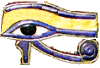
| Wadjet was usually portrayed as a rearing cobra, and as such was also known as the uraeus, the serpent image of kingship which protruded just above the forehead in most royal crowns and head-dresses. |  |
||
|
|
||||||||||||

|
Welcome to our Ancient Egyptian Home Page! |
|||||||||||
| Throughout many of the pages in this section of the site, you will come across this "find out more" icon, linking you to other pages that are related to the topic that you're currently reading on. | ||||||||||||

Discover what daily life was like for the Ancient Egyptians >>
|
|||||||
|
|||||||